
Photo Credit: Dave Hensley
Cypress Creek Watershed Monitoring Sites
The data listed below were collected via the following programs.
CRP- Data collected by Clean Rivers Program
TST- Data collected by Texas Stream Team
WPP- Data collected by Watershed Protection Plan
WMG- Data collected by the local Wimberley Monitoring Group
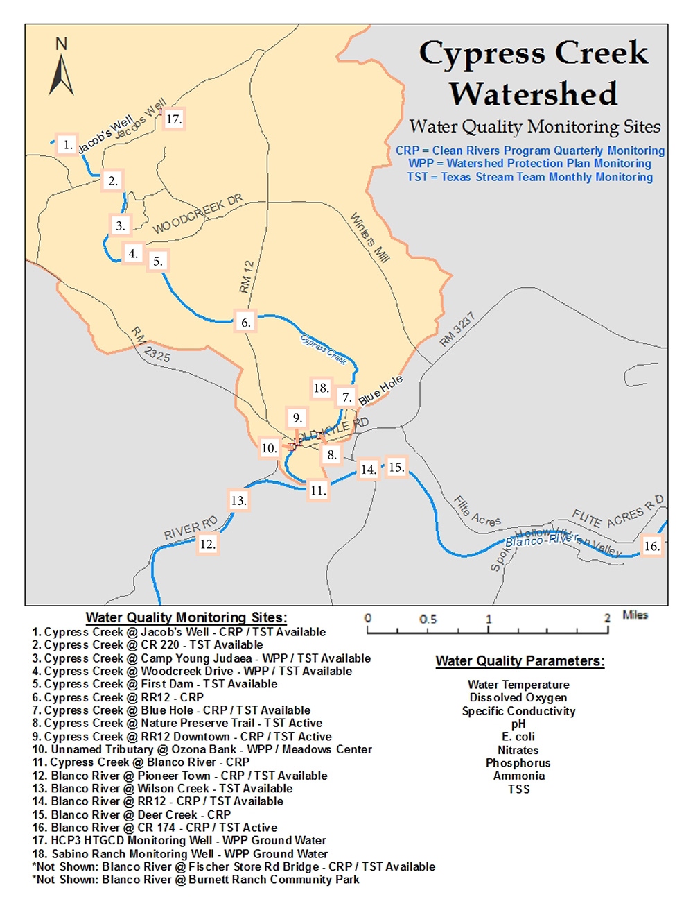
Click on a each site name below to view data for each site.
1. Cypress Creek at Jacobs Well -12677 (CRP/TST/WMG)
2. Cypress Creek at CR220 (TST)
3. Cypress Creek at Camp Young Judaea - 22109 (WPP/TST)
4. Cypress Creek at Woodcreek Drive - 22110 (WPP/TST)
5. Cypress Creek at First Dam (TST)
6. Cypress Creek at RR12 - 12676 (CRP/WMG)
7. Cypress Creek at Blue Hole - 12675 (CRP/TST/WMG)
8. Cypress Creek at Nature Preserve Trail (TST)
11. Cypress Creek at Blanco River (CRP) - 12673
12. Blanco River at Pioneer Town (CRP/TST) - 12663
13. Blanco River at Wilson Creek (TST)
14. Blanco River at RR12 (CRP/TST/WMG) - 12661
15. Blanco River at Deer Creek (CRP)
16. Blanco River at CR 174 (CRP/TST) - 12660
17. HCP3 HTGCD Monitoring Well (WPP)
18. Sabino Ranch Monitoring Well (WPP)
19. Blanco River at Fischer Store Rd. (CRP/TST)* - 12665
20. Blanco River at Burnett Ranch*
* Not shown on map
1. Cypress Creek at Jacobs Well (CRP/TST/WMG)
This site is at the perennial headwaters of Cypress Creek. The inflow of groundwater highly influences Jacob’s Well in terms of water chemistry. The creek continues upstream of Jacobs Well, but this section is usually dry unless there is precipitation. Jacobs Well is an artesian spring. The Well is approximately 3 – 4 m wide and about 13 m deep. At the bottom of Jacobs Well is an entrance to an underwater network of caves that enters into the Hays Trinity Aquifer. The spring flow of Jacobs Well is around 1 – 3 cubic feet per second and is the major source of water in Cypress Creek. The surrounding area contains limestone boulders, and the riparian vegetation consists of cypress, junipers and live oaks. Jacob’s Well is part of a nature preserve and interpretive center.
Monitoring samples at Jacob’s Well are taken off of the concrete ledge on the well side. Because this is a surface water infusion of a groundwater source, DO data is often low.
This site is also monitored by Texas Stream Team. Please visit their database for their info on this site's parameters.
Last four Quarters
| CRP Data: Cypress Creek at Jacobs Well | ||||
|---|---|---|---|---|
| Date | Flow (CFS) | DO (mg/L) | E. coli (MPN/100 mL) | Days Since Rain |
| 09/09/21 | 2.9 | 6.2 | 2 | 3 |
| 12/08/21 | 9.4 | 5.8 | 2 | 12 |
| 03/09/22 | 3.7 | 6.5 | 1 | 2 |
| 06/15/22 | 0.7 | 7.2 | 5 | 22 |
*Raw and full data sets are available upon request.
2. Cypress Creek at CR220 (TST)
This site is downstream of a low water crossing of County Road 220. Both banks of the creek are heavily wooded with live oaks and cypress trees. This site is in a flat flood plain that is undeveloped and part of a nature preserve.
This site had been monitored by Texas Stream Team. Please visit their database for info on this site's parameters.
3. Cypress Creek at Camp Young Judaea (WPP/TST)
The site is located at the Camp Young Judaea Retreat grounds, 180 acres and paths along Cypress Creek. The portion of Cypress Creek is a small impoundment, used for recreation.
This site will be monitored by Texas Stream Team; however, data is not currently being collected. Please visit their database for info on this site's parameters in the future.
Watershed Protection Plan Data for this site will be available 2018. Please check back then for their routine monitoring data.
Last four Quarters
| CRP Data: Cypress Creek at Camp Young Judaea | ||||
|---|---|---|---|---|
| Date | Flow (CFS) | DO (mg/L) | E. coli (MPN/100 mL) | Days Since Rain |
| 09/09/21 | 2.9 | 7.0 | 10 | 3 |
| 12/08/21 | 9.4 | 8.6 | 140 | 12 |
| 03/09/22 | 3. | 8.6 | 28 | 2 |
| 06/15/22 | 0.7 | 7.4 | 1 | 22 |
4. Cypress Creek at Woodcreek Drive (WPP/TST)
The site is located at the entrance of the Woodcreek subdivision, at Woodcreek Drive. Monitoring is performed just upstream of Woodcreek Drive.
This site had been monitored by Texas Stream Team. Please visit their database for info on this site's parameters.
Last four Quarters
| CRP Data: Cypress Creek at Woodcreek Drive | ||||
|---|---|---|---|---|
| Date | Flow (CFS) | DO (mg/L) | E. coli (MPN/100 mL) | Days Since Rain |
| 09/09/21 | 2.9 | 8.7 | 7 | 3 |
| 12/08/21 | 9.4 | 7.7 | 22 | 12 |
| 3/09/22 | 3.7 | 9.4 | 2 | 2 |
| 06/15/22 | 0.7 | 6.9 | 1 | 22 |
5. Cypress Creek at First Dam (TST)
This site is located beneath a low water dam that creates a small impoundment on Cypress Creek. The lake is in a suburban neighborhood of Woodcreek, TX. A golf course is located on the northern bank of the creek. Monitoring is performed upstream of the dam.
This site is monitored by Texas Stream Team. Please visit their database for info on this site's parameters.
6. Cypress Creek at RR12 (CRP/WMG)
This site is located approximately one mile north of Wimberley, at the Leeway Cottages on Scudder Ln. The inflow of groundwater highly influences RR12 North in terms of water chemistry. Access to Cypress Creek at Leeway Cottages is private. Monitoring is performed upstream of the RR12 bridge.
Last Four Quarters
| CRP Data: Cypress Creek at RR12 North | ||||
|---|---|---|---|---|
| Date | Flow (CFS) | DO (mg/L) | E. coli (MPN/100 mL) | Days Since Rain |
| 09/09/21 | 2.2 | 5.3 | 41 | 3 |
| 12/08/21 | 9.5 | 8.6 | 39 | 12 |
| 3/09/22 | 5.4 | 9.1 | 16 | 2 |
| 06/15/22 | 1.1 | 3.5 | 43 | 22 |
*Raw and full data sets are available upon request.
7. Cypress Creek at Blue Hole (CRP/TST/WMG)
This site is located at The Blue Hole, a popular local swimming hole. The inflow of groundwater highly influences Blue Hole in terms of water chemistry. The monitoring location is off of a dock along the creek bank. The water at this site is deep and clear. Cypress trees on both banks shade most of the creek. One side of the creek is a park that receives many visitors, especially during the summer. The other side of the creek is private property, and is undeveloped ranch land.
This site is also monitored by Texas Stream Team. Please visit their database for info on this site's parameters.
Last four quarters
| CRP Data: Cypress Creek at Blue Hole | ||||
|---|---|---|---|---|
| Date | Flow (CFS) | DO (mg/L) | E. coli (MPN/100 mL) | Days Since Rain |
| 09/09/21 | 3.5 | 4.2 | 26 | 3 |
| 12/08/21 | 12.0 | 7.5 | 18 | 12 |
| 3/09/22 | 6.8 | 9.1 | 17 | 2 |
| 06/15/22 | 0.2 | 3.9 | 29 | 22 |
*Raw and full data sets are available upon request.
8. Cypress Creek at Nature Preserve Trail (TST)
This site is located behind several shops and restaurants off of Old Kyle Road in downtown Wimberley. The site is slightly upstream of the Ranch Road 12 Bridge in Wimberley. The location has several cypress trees along the creek banks. The surrounding land is a well-manicured lawn that receives a lot of foot traffic from patrons of the local restaurants and stores.
This site will be monitored by Texas Stream Team; however, data is not currently being collected. Please visit their database for info on this site's parameters in the future.
9. Cypress Creek at RR12 Downtown (CRP/TST)
GBRA monitors this CRP site on Cypress Creek. The site is located at the RR12 bridge in downtown Wimberley. This is monitored on a different schedule than the rest of the CRP sites.
This site is also monitored by Texas Stream Team. Please visit their database for info on this site's parameters.
Last Four Quarters
| CRP Data: Cypress Creek at RR12 Downtown | ||||
|---|---|---|---|---|
| Date | Flow (CFS) | DO (mg/L) | E. coli (MPN/100 mL) | Days Since Rain |
| 11/4/19 | 0.3 | 7.2 | 76 | N/A |
| 1/9/20 | 95 | 11.5 | 84 | N/A |
| 2/12/20 | 3.7 | 9.6 | 2400 | N/A |
| 5/4/20 | 1.1 | 7.2 | 230 | N/A |
Seven Year Geomean
(01/11/10-10/02/17)
| CRP Data: Cypress Creek at RR12 Downtown | ||
|---|---|---|
| Flow (CFS) | DO (mg/L) | E. coli (MPN/100 mL) |
| 7 | 8.1 | 277 |
Average of all Collected Data
(03/17/98)
| CRP Data: Cypress Creek at RR12 Downtown | ||
|---|---|---|
| Flow (CFS) | DO (mg/L) | E. coli (MPN/100 mL) |
| 11 | 8.4 | 183 |
*Raw and full data sets are available upon request.
10. Unnamed Tributary at Ozona Bank (WPP/Meadows Center)
This site is located behind the Ozona Bank in downtown Wimberley. The creek is spring fed and flows during most of the year. Samples are taken before the creek enters Cypress Creek, downstream of the RR12 bridge.
11. Cypress Creek at Blanco River (CRP)
This site is located on private property where Cypress Creek enters the Blanco River. Monitoring is done just upstream of the confluence, in the middle of the stream.
Last Four Quarters
| CRP Data: Cypress Creek at Blanco River | ||||
|---|---|---|---|---|
| Date | Flow (CFS) | DO (mg/L) | E. coli (MPN/100 mL) | Days Since Rain |
| 09/09/21 | 4.0 | 7.2 | 110 | 3 |
| 12/08/21 | 11.0 | 9.4 | 180 | 12 |
| 3/09/22 | 6.5 | 10.1 | 88 | 2 |
| 06/15/22 | 0. | 6.3 | 8 | 22 |
Seven Year Geomean
(03/18/10-11/02/17)
| CRP Data: Cypress Creek at Blanco River | ||
|---|---|---|
| Flow (CFS) | DO (mg/L) | E. coli (MPN/100 mL) |
| 8 | 8.7 | 300 |
Average of all collected Data
(08/08/02)
| CRP Data: Cypress Creek at Blanco River | ||
|---|---|---|
| Flow (CFS) | DO (mg/L) | E. coli (MPN/100 mL) |
| 13 | 8.0 | 152 |
*Raw and full data sets are available upon request.
12. Blanco River at Pioneer Town (CRP/TST)
This site is located downstream of a Low Water Crossing at Pioneer Town in Wimberley, TX. Pioneer Town is private property, but it is a popular swimming area for people who pay a fee. There are several houses along the riverfront at this location. The river downstream of the low water crossing is shallow, rocky, and swift.
This site is also monitored by Texas Stream Team. Please visit their database for info on this site's parameters.
Last Four Quarters
| CRP Data: Blanco River at Pioneer Town | ||||
|---|---|---|---|---|
| Date | Flow (CFS) | DO (mg/L) | E. coli (MPN/100 mL) | Days Since Rain |
| 09/08/21 | 22 | 7.4 | 44 | 2 |
| 12/09/21 | 31 | 8.9 | 72 | 12 |
| 03/02/22 | 22 | 10.7 | 43 | 5 |
| 06/01/22 | 6.8 | 7.6 | 1 | 8 |
Seven Year Geomean
(03/18/10-11/02/17)
| CRP Data: Blanco River at Pioneer Town | ||
|---|---|---|
| Flow (CFS) | DO (mg/L) | E. coli (MPN/100 mL) |
| 61 | 8.7 | 92 |
Average of All Collected Data
(Since 02/27/03)
| CRP Data: Blanco River at Pioneer Town | ||
|---|---|---|
| Flow (CFS) | DO (mg/L) | E. coli (MPN/100 mL) |
| 138 | 8.1 | 95 |
*Raw and full data sets are available upon request.
13. Blanco River at Wilson Creek (TST)
This site is located off of River Road, at the Blanco River. Monitoring is performed in the Blanco River, just downstream of the Wilson Creek confluence.
This site will be monitored by Texas Stream Team; however, data is not currently being collected. Please visit their database for info on this site's parameters in the future.
14. Blanco River at RR12 (CRP/TST/WMG)
This site is located at the Blanco River, just downstream of the Ranch Road 12 bridge, leading to downtown Wimberley. This site showing more of an influence of local stream conditions and runoff from contributing watersheds. Issues of concern include excess sediment in the creek, high bacteria concentrations and occasionally very high nutrient levels, which indicate potential nonpoint sources of pollution including pet and animal waste, excess fertilizer application, and poorly performing septic systems.
This site will also be monitored by Texas Stream Team; however, data is not currently being collected. Please visit their database for info on this site's parameters in the future.
Last Four Quarters
| CRP Data: Blanco River at RR12 | ||||
|---|---|---|---|---|
| Date | Flow (CFS) | DO (mg/L) | E. coli (MPN/100 mL) | Days Since Rain |
| 09/08/21 | 24 | 7.4 | 200 | 2 |
| 12/09/21 | 42 | 9.3 | 93 | 12 |
| 03/02/22 | 29 | 10.7 | 45 | 5 |
| 06/01/22 | 16.4 | 7.9 | 48 | 8 |
Seven Year Geomean
(03/18/10-11/02/17)
| CRP Data: Blanco River at RR12 | ||
|---|---|---|
| Flow (CFS) | DO (mg/L) | E. coli (MPN/100 mL) |
| 70 | 9.6 | 60 |
Average of all collected date (Since 01/13/98)
| CRP Data: Blanco River at RR12 | ||
|---|---|---|
| Flow (CFS) | DO (mg/L) | E. coli (MPN/100 mL) |
| 183 | 8.9 | 64 |
WMG E.coli DATA (most recent month)
| WMG Data: Cypress Creek at Blue Hole | ||
|---|---|---|
| Sample Date | <E. coli (MPN/100 mL) | |
| 10/07/19 | 19 | |
*Raw and full data sets are available upon request.
15. Blanco River at Deer Creek (CRP)
This site is located on private property, where Deer Creek enters the Blanco River, downstream of the RR12 bridge. Monitoring is performed in the Blanco River, downstream of the Deer Creek confluence.
Last Four Quarters
| CRP Data: Blanco River at Deer Creek | ||||
|---|---|---|---|---|
| Date | Flow (CFS) | DO (mg/L) | E. coli (MPN/100 mL) | Days Since Rain |
| 09/11/19 | 46 | 9.1 | -- | 1 |
| 12/05/19 | 31.1 | 10.7 | 88 | 5 |
| 03/02/20 | 24 | 9.7 | 140 | 6 |
| 06/29/20 | 46.2 | 8.8 | 120 | 1 |
Average of all collected date
(Since 09/21/16)
| CRP Data: Blanco River at Deer Creek | ||
|---|---|---|
| Flow (CFS) | DO (mg/L) | E. coli (MPN/100 mL) |
| 97 | 9.0 | 79 |
*Raw and full data sets are available upon request.
*The purpose of this site is to monitor the outflows from the Wimberley Wastewater Project.
16. Blanco River at CR 174 (CRP/TST)
This site is located at a county road low water crossing. It is in a valley on the south bank of the Blanco River. There is some farmland and ranchland in this valley. On the north bank are several houses. Both banks are lined with cypress trees.
This site is also monitored by Texas Stream Team. Please visit their database for info on this site's parameters.
Last four quarters
| CRP Data: Blanco River at CR 174 | ||||
|---|---|---|---|---|
| Date | Flow (CFS) | DO (mg/L) | E. coli (MPN/100 mL) | Days Since Rain |
| 09/08/21 | 30 | 7.2 | 23 | 2 |
| 12/09/21 | 49 | 9.2 | 46 | 12 |
| 03/02/22 | 27 | 10.4 | 10 | 5 |
| 06/01/22 | 10.9 | 7. | 25 | 8 |
Seven Year Geomean
(03/18/10-11/02/17)
| CRP Data: Blanco River at CR 174 | ||||
|---|---|---|---|---|
| Flow (CFS) | DO (mg/L) | E. coli (MPN/100 mL) | ||
| 56 | 9.9 | 37 | ||
Average of all collected data
(Since 10/07/99)
| CRP Data: Blanco River at CR 174 | ||||
|---|---|---|---|---|
| Flow (CFS) | DO (mg/L) | E. coli (MPN/100 mL) | ||
| 134 | 9.2 | 38 | ||
*Raw and full data sets are available upon request.
17. HCP3 HTGCD Monitoring Well (WPP)
HTGCD collects water level and precipitation data
Watershed Protection Plan Data will be available 2018. Please check back then for routine monitoring data.
19. Blanco River at Fischer Store Rd (CRP/TST)
This site is located at the Blanco River, underneath the Fischer Store Road Bridge.
This site will also be monitored by Texas Stream Team; however, data is not currently being collected. Please visit their database for info on this site's parameters in the future.
Last Four Quarters
| CRP Data: Blanco River at Fisher Store Rd | ||||
|---|---|---|---|---|
| Date | Flow (CFS) | DO (mg/L) | E. coli (MPN/100 mL) | Days Since Rain |
| 09/08/21 | 28 | 7.3 | 88 | 2 |
| 12/09/21 | 28 | 8.3 | 140 | 12 |
| 03/02/22 | 15 | 8.7 | 120 | 5 |
| 06/01/22 | 14.7 | 7.2 | 7 | 8 |
Average of all collected data
(Since 09/21/11)
| CRP Data: Blanco River at Fisher Store Rd | ||
|---|---|---|
| Flow (CFS) | DO (mg/L) | E. coli (MPN/100 mL) |
| 53 | 9.2 | 45 |
*Raw and full data sets are available upon request.
20. Blanco River at Burnett Ranch*
This site is located at the Blanco River at the Burnett Ranch Community Park. This is a private park for the property owners and members of Burnett Ranch, located ten miles northwest of Wimberley, Texas. The Burnett Ranch Community is 11 acres with about 6,000 feet of frontage on both sides of Blanco River. The Blanco River rises from springs just downstream from Farm to Market 2325.
This site had been monitored by Texas Stream Team. Please visit their database for info on this site's parameters.
Wimberley Monitoring Group (WMG)
The Wimberley Monitoring Group is an initiative started by Wimberley residents and have been collecting water quality samples on a monthly basis since 1986 for their personal knowledge. E.coli data collected by the Wimberley Monitoring Group is not officially submitted to the TCEQ for the Watershed Protection Plan. Monthly results are published in the Wimberley View newspaper, if you would like to get involved or learn more about their monitoring efforts email: cypresscreek@txstate.edu
Click HERE to view the monthly data, or you can also read it in the Wimberley View.